Placeholder
Watch the webinar on this project from March 2022:
Invasion, Fire, and the Future of NW Wildlands Ventenata dubia in the Blue Mountains Ecoregion.
Project overview:
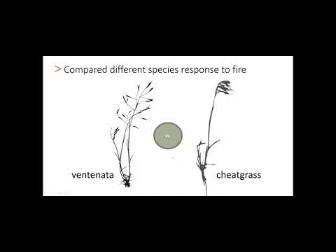
Exotic plant invasions are a growing challenge to ecosystem management and are particularly dramatic when they alter disturbance regimes beyond the range of natural variation. A relatively new invasive annual grass, ventenata (Ventenata dubia) thrives at higher elevations, threatening biodiversity and creating ecosystem-level changes. We conducted landscape and regional scale research focused on the Blue Mountain Ecoregion (BME) in the Pacific Northwest to examine the extent of ventenata invasion and associated ecosystem change.
Ventenata was first reported in North America in 1952 in Washington and has since spread to many other western states. Ventenata is an increasing concern for both public and private land managers for a variety of reasons. Like other exotic invasive annual grasses, it is aggressive and can dominate large areas across the landscape. The plant dries earlier in the summer than native species and remains highly flammable throughout the fire season creating dangerous conditions on the ground. Land managers have noted that ventenata has increased and spread over the past decade in mountain meadows and scablands of the Blue Mountain Ecoregion but the full extent of ventenata invasion was unknown prior to our research efforts.
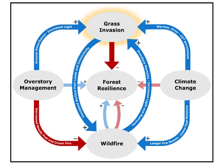
Forests may be surprisingly more vulnerable to grass invasion than conventional wisdom might suggest, and climate change, wildfire, and the unintended consequences of overstory management may increase invasion risk for forests. New research is documenting the extent to which these species could catalyze rapid and novel change and reduce resilience in forested ecosystems worldwide. From Kerns et al. 2020.
The research project had four primary objectives, outlined below:
Ventenata Occurrence in the BME
Ventenata occurrence probability (>20% cover) in the ecoregion based on model predictions. This map was created using field data, remotely sensed landscape scale phenology metrics (Nietupski et al. 2021), soil texture data, and climatic variables (PRISM). Additional details are described in Nietupski 2021. Spatial data can be provided, please contact (becky.kerns@usda.gov or nietupst@oregonstate.edu).

Objectives
Objective 1: Determine the state of the invasion, how the invasion has changed through time and what environmental and disturbance (fire and grazing) factors influence populations
Key citations:
Ridder et al. 2022. Ventenata (Ventenata dubia) Response to Grazing and Prescribed Fire on the Pacific Northwest Bunchgrass Prairie. Rangeland Ecology & Mangement, v80
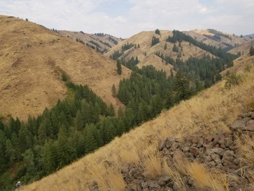
The landscape today:
Results from our occurrence map indicate that abundant ventenata populations (>20% cover) were commonly predicted in ecotones between forested and non-forested areas of the region and in shrub-grass openings of the forest matrix. About 8 % (5,454 km2) of the BME may have contained robust populations of ventenata in 2017 (map). Some parts of the region with high environmental suitability have not yet been invaded.
Invasion changes:
Landscape scale relationships with fire:
Large wildfires within forested areas experienced a greater increase in ventenata probability than similar areas that did not experience large wildfires. High burn severity was also associated with an increase in ventenata probability in some areas. The association between wildfire and invasion is likely related to the opening of canopy cover in burned areas. However, ventenata also expanded in much of the region in the absence of wildfire.
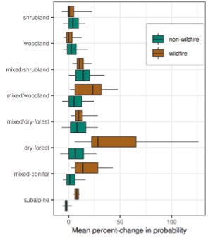
The mean percent-change in ventenata probability for wildfire and non-wildfire areas (median; 25th and 75th percentile are the upper and lower hinges, and the 5th and 95th percentile are the whiskers). From Nietupski et al. 2021.
Fire, grazing, and invasion:
We documented a 30% increase in ventenata cover and 55% increase in frequency on the Zumwalt Prairie Preserve over the past fifteen years, including areas that were not recently disturbed by fire or cattle grazing since 2006. Prescribed burning could help reduce the abundance of ventenata in areas grazed by livestock.
Objective 2: Explore how future climate change may alter the habitat suitability and potential distribution of ventenata
While current ecosystem level changes due to ventenata invasion are being realized, further changes are anticipated with predicted climate change. We are investigating how different future climate change scenarios may alter the habitat suitability and potential distribution of ventenata across the western US. This research is ongoing. Preliminary results can be found in our Joint Fire Science Final Report.
Objective 3: Examine and describe ventenata invasion dynamics in dwarf-shrublands, also known as scablands, and non-forested areas within the broader overall ecosystem
Key citations:
We found that ventenata differs from other invasive annual grasses. It heavily invades both burned and unburned dry forest, woodland, and forest scablands ranging from 4, 100 to 5,460 feet throughout the ecoregion. Ventenata’s tolerance for colder soil temperature regimes characteristic of forest scablands further separated its realized niche from cheatgrass and medusahead and expand annual grass invasion into historically resistant ecosystems. Clearly, ventenata is not “just another cheatgrass”.
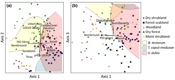
Ventenata invades areas across a wide range of understory and canopy cover, but the most heavily invaded areas were burned with <50% herbaceous cover and <20% canopy cover. Burning intensified negative relationships between ventenata cover and native species richness, annual forb cover, annual grass cover, and non-native species cover.
Overall, our results indicate that ventenata is heavily invading previously uninvaded vegetation types. This conclusion is also supported by our mapping results. The ventenata invasion is expanding the annual grass invasion footprint and potential impacts in the ecoregion, not just coexisting with other annual grasses or replacing them.
Objective 4: Estimate potential shifts in fuels and fire regimes by examining how the ventenata invasion might change fuels, fire behavior, burn probabilities, fire size, and fire effects across large landscapes now and into the future
We are examining how invasion alters simulated fire across the Blue Mountains Ecoregion using the Large Fire Simulator (FSim). Preliminary results suggest that the invasion increased simulated mean fire size, burn probability, and potential flame lengths throughout the ecoregion. Fire effects at the ecoregion-scale were relatively modest given the relatively small extent of the invasion at the landscape scale. However, invasion substantially increased burn probabilities and potential flame lengths within invaded forest openings (primarily dwarf-shrublands, aka scablands) and facilitated fire spread into the surrounding forest. Our study demonstrates how annual grass invasion can influence fire behavior in forests despite primarily invading non-forested areas, and highlights invasion as an important management issue in a montane forest-mosaic ecosystem.
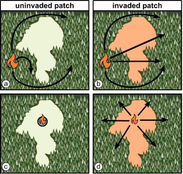
Figure: Predicted differences in fire spread between non-forest patches and the surrounding forest for an invaded and uninvaded scenario. Panels (a) and (b) illustrate differences in fire spread when a fire is ignited in the forest and travels either (a) around the uninvaded patch or (b) across the invaded patch into the adjacent forest. Panels (c) and (d) illustrate fire behavior differences when a fire is ignited within the patch. (c) Fire fails to spread into the surrounding forest because the uninvaded patch lacks a continuous fuel bed. (d) Fire readily spreads across invaded patch and into surrounding forest. From: Tortorelli et al. in review.
We are also using a fire model called FSim Large Fire Simulator to explore how the ventenata invasion may change fire behavior under future climate scenarios and to address our last research objective. The fire simulations use future climate projections obtained from an ensemble of global climate models (GCMs). A key input variable into FSim is the energy release component (ERC), which represents fuel conditions, and has been shown to correlate strongly with both observed and simulated fire activity at broad scales. The majority of GCMs project increases in ERC throughout the spring, summer, and fall relative to ERC obtained from observations at a local (Allison RAWS) weather station in the study area, serving as the benchmark weather station.
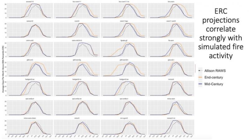
Monthly averages of energy release component (ERC) for Allison RAWS (benchmark present day weather observed), and mid- and end-century (2035-2064 and 2070-2099 respectively) projections based on 28 global climate models (GCMs). The dominant pattern of increased ERC during the spring, summer and fall suggests that the ecoregion will likely have more ignitions and fire spread, resulting in generally increased burn probabilities across the landscape. However, a few GCMs show small decreases in ERC especially for the mid-century, although this pattern is not as common by the end of the century.
Research Team

Becky Kerns, PI
USFS, PNW Research Station

John Kim, Co-PI
USFS, PNW Research Station

Meg Krawchuk, Co-PI
Oregon State University

Bridgett Naylor, Co-PI
USFS, PNW Research Station

Nicole Vaillant, Co-PI
USFS, Western Wildland Environmental Threat Assessment Center

Michelle Day, Collaborator
Oregon State University

Temesgen Hailemariam, Collaborator
Oregon State University

Robert Kennedy, Collaborator
Oregon State University

Lesley Morris, Collaborator
Oregon State University

Ty Nietupski, Graduate Student
Oregon State University

Claire Tortorelli, Graduate Student
Oregon State University
Ventenata Publications
Ridder, et al. 2022. Ventenata (Ventenata dubia) Response to Grazing and Prescribed Fire on the Pacific Northwest Bunchgrass Prairie. Rangeland Ecology & Mangement, v80
Nietupski et al. 2021. Spatiotemporal image fusion in Google Earth Engine for annual estimates of land surface phenology in a heterogenous landscape. International Journal of Applied Earth Observations and Geoinformation, v.99.
Nietupski, 2021. Graduate thesis. Characterizing an Annual Grass Invasion and Its Link to Environmental and Disturbance Factors Using Remote Sensing: New Tools and Applications
Tortorelli, et al. 2020. Expanding the invasion footprint: Ventenata dubia and relationships to wildfire, environment, and plant communities in the Blue Mountains of the Inland Northwest, USA
Kerns, et al., 2020. Invasive grasses: A new perfect storm for forested ecosystems? Forest Ecology and Mangement, v463

Closeup of Ventenata

Ventenata close-up with perennial bunchgrass grazed in foreground. Photo Credit: Ty Nietupski